 Antigua Guatemala City Guide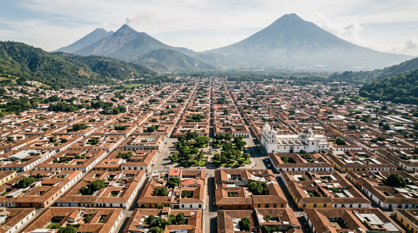
Antigua Guatemala Map: Every Pin, With the Fact That Decides It
This antigua guatemala map is the working page of this Antigua Guatemala city guide, and it carries 16 numbered pins in five colours. The same pins repeat as a text list under the map, because a list can be read on a slow phone and a pin cannot. A shortlist names the pins worth a detour, and a separate block lists the honest gaps where no coordinate could be verified. Grid coordinates come from each place's Wikidata item or its own site, and the three day-trip pins carry approximate coordinates from the research pack.
Quick answer The city in one paragraph, then the pins
Antigua Guatemala is a compact UNESCO-listed colonial grid in a Guatemalan valley at about 1,530 m, and almost every pin on the map sits within a 12-minute walk of Parque Central. The exceptions are the ridge and the volcanoes, Cerro de la Cruz a 20 to 30 minute climb, Hobbitenango a shuttle ride up the valley. Guatemala is the country, the language is Spanish, the currency the quetzal, and the practical layer sits on the plan hub.
Key takeaways
- The shortlist names the five pins that fill a first visit, with the reason each earns its slot.
- The ruin run chains four convent and church pins into one morning, two of them free to enter.
- The gaps block lists five places this map deliberately does not pin, and why no coordinate exists for any of them.
The Map: 16 Pins, Five Colours
Numbered pins, filtered by the colour chips. The list under the map repeats the same set as text, grouped the same way. Tap a pin for the fact that decides whether to go.
Squares and civic 4 pins
- Parque CentralFreeThe plaza the grid is measured from, called Plaza Mayor, Plaza Real and Plaza de Armas across its life. The Fuente de las Sirenas at its middle was built by Diego de Porres in 1737, not 1740 as many guides print.
- Santa Catalina ArchFreeBuilt from July 1693 so cloistered nuns could cross unseen, a 23 m bridge in baroque dress, restored in 2017. The famous clock was a later addition and the two Wikipedias still disagree on its decade, so this map prints no clock year.
- Palacio de los CapitanesFree facadeRoyal houses begun in 1558, treasury, jail and army quarters in colonial times, now INGUAT offices, police headquarters and the governor's seat. A colonnade to walk past on the way south of the park.
- INGUAT tourist officeThe official help desk at 5a Calle Oriente No. 11, Local 2, phone +502 2290 2800, weekdays morning to late afternoon, published closing times conflict. Pin is the city-centre reference point, the office sits within a block.
Churches and ruins 4 pins
- San Jose CathedralParish free, ruins fee not statedFirst stone 1545, consecrated 1680, a metropolitan by 1743, wrecked by the 1773 Santa Marta earthquakes. The working parish occupies one rebuilt section, the rest stands as the ruins with the crypts.
- La MercedFreeThe city's best baroque facade, built 1749 to 1767 and undamaged by the 1773 quakes because it was practically new. Its Fountain of los Pescados, 27 m across, is among Latin America's largest colonial fountains.
- San FranciscoShrine fee not statedCurrent church inaugurated 1702 under Diego de Porres with 16th-century fabric in the site. Santo Hermano Pedro is enshrined here, canonised in 2002, and his tomb draws pilgrims by the thousand.
- Convento de las CapuchinasAccess paid, fee not statedApproved in 1725, the last convent built in the city, with a circular courtyard of cells around a common chamber. Owned by the heritage trust CNPAG, access is paid, and no official tariff is published anywhere.
Views and ridge 2 pins
- Cerro de la CruzFreeThe cross viewpoint with the whole grid below and Agua behind, the city's signature photo. INGUAT describes a signposted trail of 20 to 30 minutes from the centre, no fee exists, and the reported hillside shuttle has no official trace.
- Hobbitenango$8 day pass, shuttle $8A hobbit-themed eco park on the ridge above the valley, 15 minutes by vehicle. The park quotes its own prices in dollars, $8 entry plus $8 shuttle from the Antigua office, shuttles on fixed windows, arrive 30 minutes early.
Museums and houses 2 pins
- Casa Santo DomingoMuseum price not statedThe monastery turned museum-hotel at the east end, six permanent museums plus galleries in nave, cloister and crypts. Museums run 9:00 to 18:00 Monday to Saturday and 11:00 to 18:00 Sunday, may close early without notice, and no price is published online.
- Finca La AzoteaMuseums Q40 ($5.24)A working cultural farm in Jocotenango, northwest of the grid, with the Museo del Cafe daily 9:00 to 18:00 and the K'ojom music museum. Museums Q40 adult, Q30 child, guided tours Q100 ($13.09) at fixed hours.
Beyond the valley 4 pins
- Volcan de AguaStatus and fee not statedThe cone that fills every photo from the grid, 3,766 m by common account. No official hiking status, fee or guide rule could be verified from any agency, so this map pins it and prints nothing else.
- PacayaPark fee not publishedThe active volcano that runs as a half-day trip, degassing at the Mackenney crater per CONRED, tour cards from $23. No agency publishes its park entry fee, a Q50 forum figure is unverified, so no fee appears on this map. Pin approximate.
- Panajachel and Lake AtitlanShuttle $25 each wayThe lake day, about 2.5 to 3 hours away by shuttle across the valley rim. Shared vans run from $20 to $25, Adrenalina charges $25 with three daily departures, 48 hours notice. Pin approximate.
- MonterricoReserve fee not statedThe black-sand Pacific coast and the turtle reserve, hours 07:00 to 17:00 daily, nesting season July to December. The one beach day on the tour boards, priced at $120 with the drive through sugar cane. Pin approximate.
Grid coordinates come from each place's Wikidata item or the venue's own site, checked entity by entity. The three day-trip pins carry approximate research-pack coordinates. The map was assembled with the same figure set as the rest of this guide, and where a page and this map ever disagree, the page is the one kept current.
The Five Pins Worth a Detour
Sixteen pins is more than any one visit needs, so this is the short cut: the five that fill a first itinerary, each with the reason it earns the slot and the price of getting in, read from the venue's own figures.
| Pin | The reason | Getting in |
|---|---|---|
| Santa Catalina Arch | The single image of the city, and the street under it is the walk everything else starts from | Free, street level |
| Parque Central | The plaza the grid is measured from, fountain of 1737 at the middle, benches in the shade | Free |
| Cerro de la Cruz | The whole grid and the volcano in one frame, the photo people come home with | Free, 20 to 30 minutes up the signposted trail |
| La Merced | The best facade in the city and the square that anchors the north edge | Free |
| Casa Santo Domingo | Six museums through nave, cloister and crypts in one compound, the deepest hour on the map | Museum price not published online, confirmed at the desk |
Ranked by what a first visit loses by skipping them, not by stars. The ruin run below is the other shape of day, for readers who would rather walk less and stand inside more.
The Pin Ledger: All 16, At a Glance
The same 16 pins as a directory, colour, entry figure and the time to allow, so the page works as a printed list too. An empty entry cell means no figure is published to print, and the pin notes above carry the finding.
| Pin | Colour | Entry | Time to allow | Walk from the park |
|---|---|---|---|---|
| Parque Central | Civic | Free | 30 to 45 minutes with the benches | In the middle |
| Santa Catalina Arch | Civic | Free | 10 minutes with photos | About 150 m |
| Palacio de los Capitanes | Civic | Free facade | 5 minutes | About 490 m |
| INGUAT tourist office | Civic | Free | As needed | About 400 m |
| San Jose Cathedral | Church | Parish free, ruins at a desk fee | 45 to 60 minutes | About 380 m |
| La Merced | Church | Free | 20 to 30 minutes | About 230 m |
| San Francisco | Church | Shrine asks a donation | 30 to 45 minutes | About 790 m |
| Capuchinas | Church | Paid, figure not stated | 30 to 45 minutes | About 170 m |
| Cerro de la Cruz | Views | Free | 60 to 90 minutes with the climb | 500 m but uphill |
| Hobbitenango | Views | $8 plus $8 shuttle | Half a day | Vehicle only |
| Casa Santo Domingo | Museums | At the desk, not stated online | 2 to 3 hours | About 620 m |
| Finca La Azotea | Museums | Q40 ($5.24) museums | Half a day with lunch | About 2.1 km |
| Volcan de Agua | Beyond | Not stated | A full day, status unverified | Vehicle, then a hike |
| Pacaya | Beyond | Tour from $23, park fee not published | 6 to 7 hours | Vehicle, then a hike |
| Panajachel and the lake | Beyond | Shuttle from $20 | A full day | Vehicle, 2.5 to 3 hours |
| Monterrico | Beyond | Tour at $120 | A full day | Vehicle, about 2.5 hours |
What the Five Colours Encode
Every colour is a decision, not a decoration, and the pins inside each one behave the same way.
Squares and civic (bronze)
Parque Central, the Santa Catalina Arch, the Palacio de los Capitanes colonnade and the INGUAT office. All free, all within three blocks of the park. These are the pins you pass anyway, so they cost nothing but attention.
Churches and ruins (jade)
The Cathedral, La Merced, San Francisco and Capuchinas. The line that decides them is simple. Worship spaces are free or ask a small unstated fee, while the heritage-trust ruin, Capuchinas, is paid and publishes no tariff anywhere online.
Views and ridge (carmine)
Cerro de la Cruz is free on foot up a signposted trail, and Hobbitenango sits at $8 entry plus an $8 shuttle. One is a climb, the other is a ticketed outing, and the price gap is the choice.
Museums and houses (green)
Casa Santo Domingo and Finca La Azotea are the two compounds where a ticket buys several collections at once. They are also the only two pins whose museums print real opening hours, 9:00 to 18:00 and 11:00 on Sunday for the first, daily hours for the second.
Beyond the valley (slate)
Agua, Pacaya, the lake and the coast are off-scale by definition, pinned because people search for them. The honest note is that three summits of the region stand closed or unverified, and the hiking page tracks which.
How the City Is Shaped, and Why the Pins Cluster
The pin pattern is not random, it is the city's history drawn in dots.
| From Parque Central to | Straight line | Our walk estimate | The catch |
|---|---|---|---|
| Santa Catalina Arch | about 150 m | 2 minutes | The street is the photo, walk it slowly |
| Capuchinas | about 170 m | 3 minutes | Paid entry, fee not stated |
| La Merced | about 230 m | 3 minutes | Best light is early morning |
| San Jose Cathedral | about 380 m | 5 minutes | Ruins fee not stated |
| Palacio de los Capitanes | about 490 m | 6 minutes | Facade only |
| Casa Santo Domingo | about 620 m | 8 to 10 minutes | East and gently uphill |
| San Francisco | about 790 m | 10 to 12 minutes | Pilgrim crowds at the shrine |
| Cerro de la Cruz | about 500 m but uphill | 20 to 30 minutes | The signposted trail, no fee |
| Finca La Azotea | about 2.1 km | 25 to 30 minutes | Crosses into Jocotenango |
Wealth built the centre first
The grid sits on the valley floor at about 1,530 m with the park at its middle, and the civic and church pins crowd within four blocks of it. The museum compounds push east and northwest, Casa Santo Domingo toward the old monastery end and Finca La Azotea out into Jocotenango. The views sit on the rim, Cerro de la Cruz on the near hill and Hobbitenango far up the valley.
Wealth built the centre first and the convents took the edges, and the pins still follow that money. So plan days by clusters, not by list order, and nothing on the grid costs you more than ten minutes of cobbles.
The Civic Pins: What the Free Squares Hold
Four pins cost nothing and carry most of the city's history, if you know what you are standing in front of.
The arch was begun in July 1693 so the nuns of Santa Catalina could cross from their convent to the other side without being seen, and it works as a bridge, 23 m of it. The clock in its tower is a French mechanism that must be wound every three days, was damaged when the 1976 earthquake stopped it, and was restarted in 1991. The municipality owns the arch, the former convent beside it is now a private hotel, and the whole structure was restored in 2017, which is why it looks better than its age.
Parque Central has carried three names, Plaza Mayor, Plaza Real and Plaza de Armas, and its fountain, the Fuente de las Sirenas, was built by Diego de Porres in 1737. Across the south side stands the Palacio de los Capitanes, begun in 1558 as the royal houses with treasury, jail and army quarters behind the colonnade, and on the other side the City Hall rebuilt after the 1751 earthquake. The tourist office two blocks east handles the questions the pins do not answer.
Getting to the Rim Pins Without a Car
Two of the sixteen pins need a vehicle, and the vehicle hours are published, which makes them plannable.
Hobbitenango runs its own shuttle from the Antigua office on fixed windows: up to the park between 8:00 and 10:00 in the morning and again between 14:00 and 16:00, and back down at 9:00 to 11:00 in the morning plus 13:00, 15:00, 17:00 and 18:00. The office asks arrivals 30 minutes before the shuttle hour, the round trip is $8 on top of the $8 day pass, and parties of ten or more must arrange transport with the park's sales desk instead. Cerro de la Cruz needs none of this, the signposted trail starts at the north edge of the grid and takes 20 to 30 minutes, and no official shuttle service exists despite what forum posts report.
For the beyond-the-valley pins the choice is a tour seat or a shuttle, and the tours hub compares them on one table.
The evening rule that catches people
Tuk-tuks stop working about 22:00, and the last Hobbitenango shuttle down runs well before that, so a ridge day ends earlier than a grid day. Plan the rim for the morning, when the volcanoes are visible and the afternoon cloud has not arrived.
The Viewpoints, Compared
Three ways to see the valley, and only two of them come with usable facts.
The free climb and the ticketed ridge
Cerro de la Cruz is the free one, a signposted 20 to 30 minute climb from the centre with the whole grid below and Agua behind. A hillside shuttle is reported but no official trace of one exists, so plan on foot. Hobbitenango is the themed ridge park at $8 entry plus an $8 shuttle, running on fixed windows from the Antigua office, arrive 30 minutes early. Both are covered in more depth on the best views page.
The cone, and the closure that frames it
Volcan de Agua is the cone in every photo, and the honest status is that no agency publishes a hiking status, fee or guide rule for it, so nobody should promise the climb. Fuego and Acatenango have been suspended since 4 August 2026, and Pacaya runs under CONRED watch with degassing reported at the Mackenney crater. Read the Pacaya page before paying for any lava day.
The Ruin Run: Four Pins in One Morning
One shape of day beats any list of highlights here, four jade pins chained in a loop that never leaves the grid.
The chain
Start at Capuchinas, approved in 1725 and the last convent built in the city, with its circular courtyard of cells, paid entry and no published fee. Then the Cathedral ruins, which carry 1545 and 1680 in one story and the 1773 earthquakes in the rubble. Third, San Francisco, the 1702 church that holds the shrine of Santo Hermano Pedro, canonised in 2002.
End at La Merced, finished in 1767, in time for lunch hours on its square. Nothing in the chain is more than 12 minutes' walk from the park.
Two honest notes
No official fee exists online for Capuchinas or the cathedral ruins, so carry small quetzal notes. Hours for the ruin sites generally run 9:00 to 17:00 per the official museum list, though the individual sites publish none of their own.
The Gaps on This Map, and Why Each Is a Finding
What a map refuses to pin is information too, so here is every deliberate absence and its reason.
Five places with no coordinate, and one rule
- No pin for the municipal market. No Wikidata item exists, the municipality publishes no address or hours for it, and INGUAT names only generic artisan markets, so the map cannot place it honestly. What is known sits on the market page. (searched Wikidata, muniantigua.gob.gt and INGUAT) - No pin for Chocomuseo. The venue publishes an address, 4a Calle Oriente No. 8, but no coordinate, and a geocoded guess would put the pin in the wrong doorway.
(chocomuseo.com) - No pin for Santa Clara. The convent ruin has no Wikidata item, the heritage trust that owns it publishes no website, and no fee or hours exist to print. (searched Wikidata and CNPAG) - No pin for Finca Filadelfia. The estate has no official site, only a login-walled Facebook page, so no coordinate, price or tour hour is verifiable. (searched for an official domain) - No pin for Santo Domingo del Cerro. The cultural park publishes no coordinate and no visitor access method, not even which vehicle reaches it.
(casasantodomingo.com.gt) - No fee on the church pins. The parish and ruin fees that do exist are simply not published online, so the pins say free where worship is free and not stated where a desk charges. (facts pack, checked against each venue's own presence)
The Museum Pins: What the Ticket Actually Buys
Two compounds on the map sell collections rather than single rooms, and both publish their hours.
Casa Santo Domingo spreads six permanent museums and two galleries through a monastery, the collections running from colonial art to a Maya archaeological set dated 200 to 900 AD, liturgical silver from the 16th to 18th centuries and a 19th-century pharmacy, with the nave, cloister and crypts as exhibit space in themselves. Hours run 9:00 to 18:00 Monday to Saturday and 11:00 to 18:00 on Sunday, the site warns the museums may close early without notice, and there are no guided tours, so the price conversation happens at the desk and nowhere online.
Finca La Azotea in Jocotenango works differently, a working farm that sells its pieces separately, museums at Q40 ($5.24) for adults and Q30 ($3.93) for children, guided hours at 10:00, 11:00 and 14:00 to 16:00 at Q100 ($13.09), a two-hour chocolate workshop at Q180 ($23.56), horse rides at Q100 for half an hour and minigolf at Q30 ($3.93). The Museo del Cafe opens daily 9:00 to 18:00 and the K'ojom music museum 9:00 to 17:00, and the farm's general entry is charged separately from all of it, a fact the ticket desk will confirm before you plan around it.
What the Season Changes
The same pins behave differently through the year, and two of them change the most.
Rain, cloud and a closed perimeter
This map is a dry-season picture. From May to October the afternoon storm redraws every walking plan, September hardest at 311 mm over about 28 rainy days, and the rim pins, Cerro de la Cruz and Hobbitenango, lose their view in cloud. Casa Santo Domingo's museums may close before their posted hour without notice, the official site says so itself.
The 30-year table sits on the weather page.
Holy Week
In Holy Week the municipality closes central streets to vehicles from early morning on procession days, and the arch and cathedral pins sit inside the perimeter, so read the Semana Santa page before pinning a route that week.
From the Pins to the Pages
Every pin here has a page behind it, and these hubs hold the rest.
How This Map Was Assembled
A map is only as honest as its coordinates, so here is the method in four sentences.
Every grid pin carries a coordinate taken from the place's Wikidata item or from the venue's own site, looked up entity by entity rather than searched by name, which is the same method the big reference maps use. The three day-trip pins carry research-pack coordinates that the pack itself marks approximate, and the pin notes say so. Where a place publishes no coordinate, no pin was drawn, and the gap is recorded in the gaps block with the reason, because a guessed pin is worse than a documented absence.
The entry figures come from the venue's own published prices, the research packs behind them were read as a set, and where a page and this map ever disagree, the page is the one kept current.
Antigua Guatemala Map: Questions
Where is Antigua Guatemala?
Antigua Guatemala sits in Guatemala, in the Sacatepequez department, about 40 to 45 km from Guatemala City's La Aurora airport, at roughly 1,530 m above sea level. The drive runs 45 minutes to an hour and a half depending on capital traffic. The arrival options, prices and the rest of the practical layer sit on the plan hub.
What is Antigua Guatemala famous for?
The UNESCO-listed colonial grid, the Santa Catalina Arch, the ruined churches left by the 1773 earthquakes and the volcano views over all of it. The shortlist on this page picks the five pins that fill a first visit, each with the reason it earns the slot and the price of getting in, starting from the arch and the plaza.
Can you walk around Antigua Guatemala?
Yes, comfortably. The pins sit minutes apart, the arch about two minutes from the park and San Francisco about ten to twelve, with all the distances in the shape table. Tuk-tuks cover the gaps at the Q10 municipal tariff, though drivers often ask more, and they stop working about 22:00.
Can I download this map offline?
No official paper or PDF map is published by the city, so there is nothing to download from the municipality. The practical route is to use each pin's map link and download the Antigua area inside the Google Maps app before you arrive, which works with the pins on this page.
Why does the map show 16 pins and not more?
Because every pin here carries a coordinate this guide could verify from Wikidata or the venue's own site. Places without one, like the municipal market, Chocomuseo, Santa Clara, Finca Filadelfia and Santo Domingo del Cerro, are held out deliberately, and the reason for each absence is documented in the gaps block.
Which pins are free?
The civic squares, the arch, the Capitanes facade, La Merced and Cerro de la Cruz are all free, and the park costs nothing. The rest carry their status in the pin notes, with several fees listed as not stated because no venue publishes them. The zero-dollar list is expanded on the free things to do page.
Are the pins listed in walking order?
No, the pins are numbered by colour group, not by route. The walking order that works is in the ruin run for the churches and in the shortlist for a first day, and the shape table prints the walk minutes between the park and every pin.
Which viewpoint is worth it if I only climb once?
Cerro de la Cruz, because it is free, signposted, 20 to 30 minutes up, and frames the whole grid with the volcano behind, which is the photo the city is known for. The viewpoints guide compares it with the ridge park and the closed big cone.
What is the best time of day to use this map?
Morning, and the reason is on the pins themselves. The arch photographs best early, Cerro de la Cruz loses the volcano to afternoon cloud, and the rainy season storms arrive like clockwork after midday from May to October. The weather page has the 30-year table behind that pattern.
The Ground the Pins Sit On
Three street-level films of the grid, the fastest way to learn the blocks the pins number.
4K Guatemala Walk | Antigua City Center | A Beautiful Colonial City Surrounded by Volcanoes
The centre at walking pace, the frame the pin map covers.
Video: 4K Walking TravelAntigua Guatemala walking tour on historical center 4K
The historic core block by block, from the park outward.
Video: Wandering PeteANTIGUA, Guatemala | 4K 60fps Walking Tour
A second pass through the grid with the volcano closing every street view.
Video: EchoStepsVideos load from YouTube only when you press play.
We may earn a commission if you book through one of our links, at no extra cost to you. Full affiliate disclosure